Description
****Please make sure macros are enabled in your Excel to run this application.****
Introduction
DesGo is the new tool created to keep in mind to streamline the very critical decision to Go or Not to Go for a marine operation.
Marine Operation can be explained as a cumulative set of activities needed to perform work, such as Transportation, Heavy-Lift, Subsea Installation
PipeLay, Cable lay, Dredging, Mooring, etc. Such a critical Go-No Go decision is a very critical moment and has a significant financial impact, is taken in the
presence of the Captain of the vessel, Offshore Installation Manager (OIM), Marine Warranty Surveyor (MWS), Client Representative, Field Engineer/
Project Engineer and selected a few others such as critical equipment operators.
The decision is made keeping in view the weather forecast in the coming days, operational capability, and duration of the operation. If the weather forecast
from the official source is below the operational capability for the entire period of the operational duration (plus a reserve/contingency period),
and assuming the vessel is fully prepared and is on standby, the decision can give a strong indication to go ahead. Note that the result of this tool does not
supersede the decision of the driving team.
When to use the tool?
This tool is a lightweight onboard tool that can be simply used over a PC or a tablet. It is important that the operation operability limit is PRE-FED
This is a one-time activity. Before the commencement of operation, the forecast can be read from the forecast report regularly and the dashboard list can be
updated regularly and presented as a summary to the team.
Who are the users?
1. Project Engineer o/b vessel
2. Offshore Installation Manager
3. Captain
4. Site office supporting the project
5. Works Manager/Lead PE/ PM
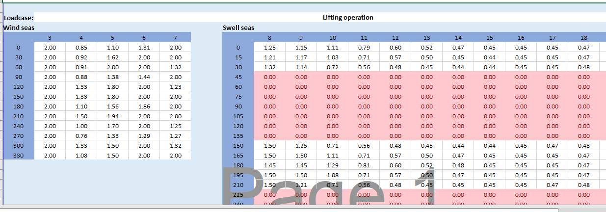
What are the inputs?
1. The Hs operability table is pre-fed into the sheet. This can be done by an office-based marine engineer/project engineer. The operability table is the
outcome of various hydrodynamic analyses. For an operation, for various incoming directions and periods, the limiting sea state is provided.
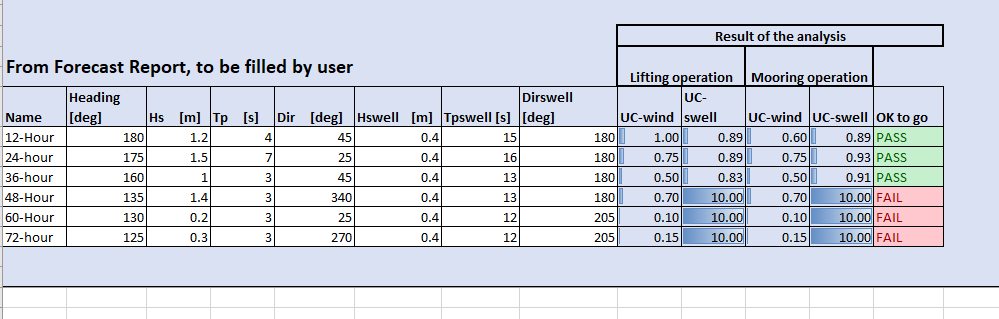
2. At the site, Metocean forecast report results are fed manually
6 instances of (Instances can be selected based on length of the operation and can be generated as T+3-hour, 6-hour, 9-hour…. ) time slots.
1…..Vessel heading from true North
2…..Wind-driven significant wave height (Hs)
3…..Corresponding Tp
4…..Incoming wave direction
5…..Swell driven significant wave height (Hswell)
6…..Corresponding Tp (note that swell below Tp of 7-8s is rare)
7……Incoming wave direction
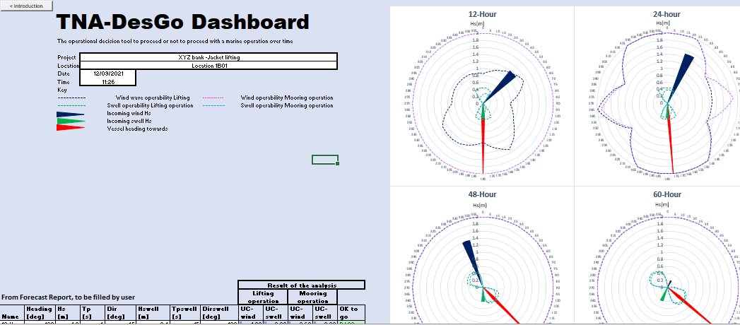
What are the outputs?
The output is presented as 6 dials showing incoming wave direction (wave and swell) with respect to vessel heading to show if the incoming wave height
is higher or lower than the operability limit. If the incoming wave height is higher than the limit, this shall be a FAIL scenario, else pass. A unity check is also added
per time slot to see if the operation narrowly exceeds the criteria.
The dashboard can be printed to be used in a presentation.
Note for the customer
The format in this tool uses 4 operability tables. See the explanation in the tool on how to use it.
If a user wishes to extend the number of operability tables or change it or use other environmental parameters like current, etc, this can be implemented. Please
contact info@thenavalarch.com for the customization.
Reviews
There are no reviews yet