Our oceans are interspersed with human activities: be it fishing, marine transportation, or offshore operations. These operations usually involve assets worth multiple million dollars, be it the produce or the equipment or in most cases, the human life. Produce from the ocean can be fish, petroleum or natural gases, rare earth materials and minerals, or deep-sea research. The equipment used could either be buoyant such as various transportation ships, operation vessels (PSVs, offshore heavy lift vessels, pipelay vessels, etc.), rigs, drillships, FPSOs, or even recreational and research vessels. Further, there are UAVs, ROVs, trenchers, or even divers. All these equipment, be it manned or unmanned, can only operate within a certain environmental condition: beyond which the equipment might get damaged or there is a threat to human life.
The Threats
The threats are significant and varied but they can be broadly classified into the following categories:
- Threat to the equipment: Most of these equipment are expensive and sensitive. Operating in rough seas can lead to weld failure, accidental slippage of gears and wires, fishing net loss, bending due to wave loads, or even vessel capsizing.
- Threat to the surrounding: Cranes could swing and break and fall on the deck, oil leakage, fall on nearby assets, power cables.
- Threat to marine life: Oil spill, explosions, dropped objects on reefs
- Threat to humans: Dropped objects on humans, man overboard, sea sickness, injuries, accidents, and fatalities.
Point of no return
Oceans are vast and often quite random. Also, many marine operations are performed hundreds and even thousands of kilometers away from the coast. Freak events like tsunami and cyclones are highly unpredictable in their pattern, severity, and course. Mere watchkeeping personnel cannot estimate the size and severity of the incoming storm and warn the mates. Even if he does, it is often too late to respond and escape such weather conditions, since the vessel needs to un-moor and abandon the asset and leave which often takes hours before departure. It is often difficult to reach a safe refuge since ocean storms run into hundreds of kilometers. There is a need to understand the incoming storm sufficiently in advance in order to take the decision to continue, survive or abandon the operation.
Weather prediction
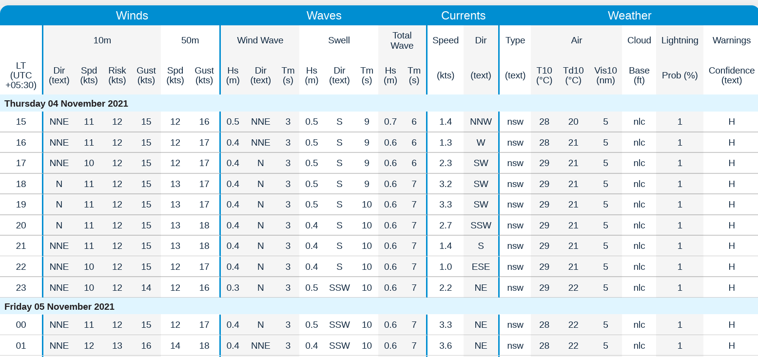
It is a common practice in the marine sector among all vessel or offshore operators to get weather prediction reports from reliable sources. This is mandated by IMO guidelines to take sufficient weather forecaster data before and during any sailing or offshore operation. The sources are government or private but authorized agencies which have the right tool (such as SWAN model), right equipment (petabytes of supercomputers), and weather scientists to study and model complex environmental phenomena into mathematical parameters which are understandable in the industry. Typically, the information includes Wind speed (10m above sea level), Wave Height, Wave period, Swell height and period, respective directions, temperature, and visibility. The scientists utilize buoy (WaveRider®, MetMast) data, local metocean office data as well as satellite observations to process and create time and spatial distribution of weather, to be able to predict the environment in the future. The information is matched against decades (often 25-30 years) of historical data. Hindcast as well as historic data is utilized to generate weather forecasts which are available in public domain for seafarers to access and review or further postprocess to their understanding.
This allows to foresee the incoming weather condition at their location and decide the best course of action. Forecasts are often seen with the outlook of 3, 6, 9 or 12, 24, 48, 72 hours within which the metocean reports have certain degree of reliability. Sometimes a 15-day forecast is also requested for high-level understanding for long term preparation. Note that no metocean forecast is 100% accurate and often seafarers utilize an ensemble of forecasters to achieve certain reliability and confidence over the prediction.
Weather assessment
A mere observation of the predicted weather is not good enough. The seafarers (or the supporting marine engineers) compare the predicted weather against the capability of their assets. The capability of their asset is defined in terms of a number of vessel operation limits or equipment parameters. An example is as follows:
Maximum allowed roll motion of the vessel = 5 degrees, and/or
Maximum allowed seafastening vertical load = 6tons, and/or
Maximum DAF in crane hoist wires = 1.3, and/or
Maximum tension in pipe = 140t
And so on.
The limits are established by asset owners who have tested their equipment through lab tests or oceanic conditions and are specified in the design basis of the project. In a single operation, there could be multiple asset owners involved (Crane operator, vessel operator, DP operator /mooring, fender, anchor, rigging, tool, ROVs, divers), each having its operational limit to operate within.
While most nautical operators such as containerships or tankers have pre-defined weather limits to operate within, the offshore operations involving cranes, heavy-equipment or pipelines vary from project to project. The marine engineer prepares simulations where all the relevant equipment is combined in the form of a mathematical model and their behavior is analyzed in a certain sea state. How the simulations are prepared is a separate subject of discussion. The outcome of the analyses is a summary of ALLOWED SEASTATE per operation (lifting, DP, mooring, seafastening, cable, or pipelaying)
All the allowed seastates are combined based on simultaneous applications to determine the most conservative seastate limit. These limits are interspersed over 360degrees around the vessel or equipment. Sometimes an additional safety factor is also applied based on the risk appetite of the company, contractor or the warranty issuer. This process is called weather assessment. (Guidance of procedure in DNV-ST-N001). The weather limits are provided to the Vessel bridge to compare the weather forecast to Go or Not-to Go ahead for the operation.
TheNavalArch’s DesGo Decision Support Tool:
There are still certain difficulties at this final stage of decision, because:
- The weather operation limit for the operation is typically based on vessel directional convention (i.e. Vessel Bow is 180deg) whereas the weather reports are provided against global conventions.
- Further, the environment components (Wind wave, wind, swell or current) are not always unidirectional.
- Thirdly, the directions and magnitudes can change over time and long-term prediction means reviewing the predictions again unless sufficient outlook is overseen.
This can cause confusion and non-clarity in the basis of the decision whether to proceed or not to proceed with the operation. With the “TheNavalArch DesGo” (Decision of Go-Ahead) Tool, the integration of the weather forecast and operability limit is integrated into a very intuitive Dashboard which can be demonstrated or printed by the on-board personnel and used in the Go-No Go decision. Further, if it allows, any improvement in the weather operability can be seen by changing the vessel heading with respect to the global north can be seen and discussed. This check can also be performed even during the engineering stage if the most probable incoming wave and swell direction are known.
We at TheNavalArch aim towards operational effectiveness and clear and concise graphic representation of conclusion is the right way towards decision making, both at conceptual or at the execution stage.
Disclaimer: This post is not meant to be authoritative writing on the topic presented. thenavalarch bears no responsibility for the accuracy of this article, or for any incidents/losses arising due to the use of the information in this article in any operation. It is recommended to seek professional advice before executing any activity which draws on information mentioned in this post. All the figures, drawings, and pictures are property of thenavalarch except where indicated, and may not be copied or distributed without permission.
Webcast: Rapid Rigging
Learn a rapid and practical method for generating accurate rigging arrangements and estimating rigging loads in one hour or less using simple engineering principles and streamlined workflows. TECHNICAL WEBCAST OVERVIEWLifting operations can be executed far more...

TheNavalArch’s Interview Series: Peter Farthing (MD, Sensor Technologies)
Peter FarthingManaging Director of Sensor Technologies Ltd and CEO of Advantec Group Limited Interview Introduction TheNavalArch's Interview Series is an endeavor to get insights from the best engineering and business brains in the industry and present them to its...
TheNavalArch Interview Series: Capt Robin Perera
TheNavalArch's Interview Series is an endeavor to get insights from the best engineering and business brains in the industry and present them to its users for the larger benefit of the maritime community. Leaders share their experiences and ideas that readers can gain...
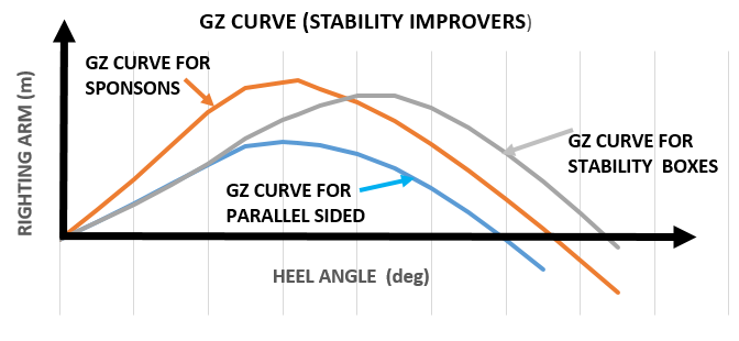
Offshore Installation Vessels Stability Considerations
OFFSHORE INSTALLATION VESSELS STABILITY CONSIDERATIONS By Alan Crowle, BSc, MSc, MScbyRes, CEng, CMarEng, FRINA, FMAREST, FSCMS University of Exeter, College of Engineering, Renewable Energy Group INTRODUCTION The temporary phases of an offshore structure transport...
TheNavalArch Interview Series: Mr Victor Valera
TheNavalArch's Interview Series is an endeavor to get insights from the best engineering and business brains in the industry and present them to its users for the larger benefit of the maritime community. Leaders share their experiences and ideas that readers can gain...
TheNavalArch Interview Series: Mr Steven Lu
Mr. Steven LuManaging DirectorEpoch Offshore Engineering (Shanghai) Co., Ltd. TheNavalArch's Interview Series is an endeavor to get insights from the best engineering and business brains in the industry, and present them to its users for the larger benefit of the...
TRANSPORT VESSELS FOR FLOATING WIND
By Alan Crowle, BSc, MSc, CEng, CMarEng, FRINA, FMAREST, FSCMS Masters by Researcher, University of Exeter, College of Engineering, Mathematics and Physical Sciences, Renewable Energy Group SUMMARY Floating wind turbine construction is a large logistical exercise. The...
TheNavalArch Interview Series: Mr. Balakrishna Menon
Mr. Balakrishna MenonEngineering Director Mooreast (Asia) Pte Ltd TheNavalArch's Interview Series is an endeavor to get insights from the best engineering and business brains in the industry, and present them to its users for the larger...
Floating Rice Fields, the quest for solutions to combat drought floods and rising sea levels
by Lim Soon Heng, BE, PE, FSSS, FIMarEST Founder President, Society of FLOATING SOLUTIONS (Singapore) Abstract Amazing as it seems, there is a case for growing rice on floating platforms in the sea. The capital expenditure to develop this is offset by the opportunity...
CAPSIZE OF LIFTBOAT IN TRANSIT
This paper was originally presented in the 27th Offshore Symposium, February 22nd, 2022, Houston, Texas Texas Section of the Society of Naval Architects and Marine Engineers It has been reproduced here for the readers of TheNavalarch INTRODUCTION In 1989 a Class 105...
Please check out TheNavalArch’s product DesGo – Decision Support tool for Maritime Operations:
DesGo – Decision Support Tool for Marine Operations – TheNavalArch